Open full-size vector drawing · Use written dimensions; do not scale the screen.
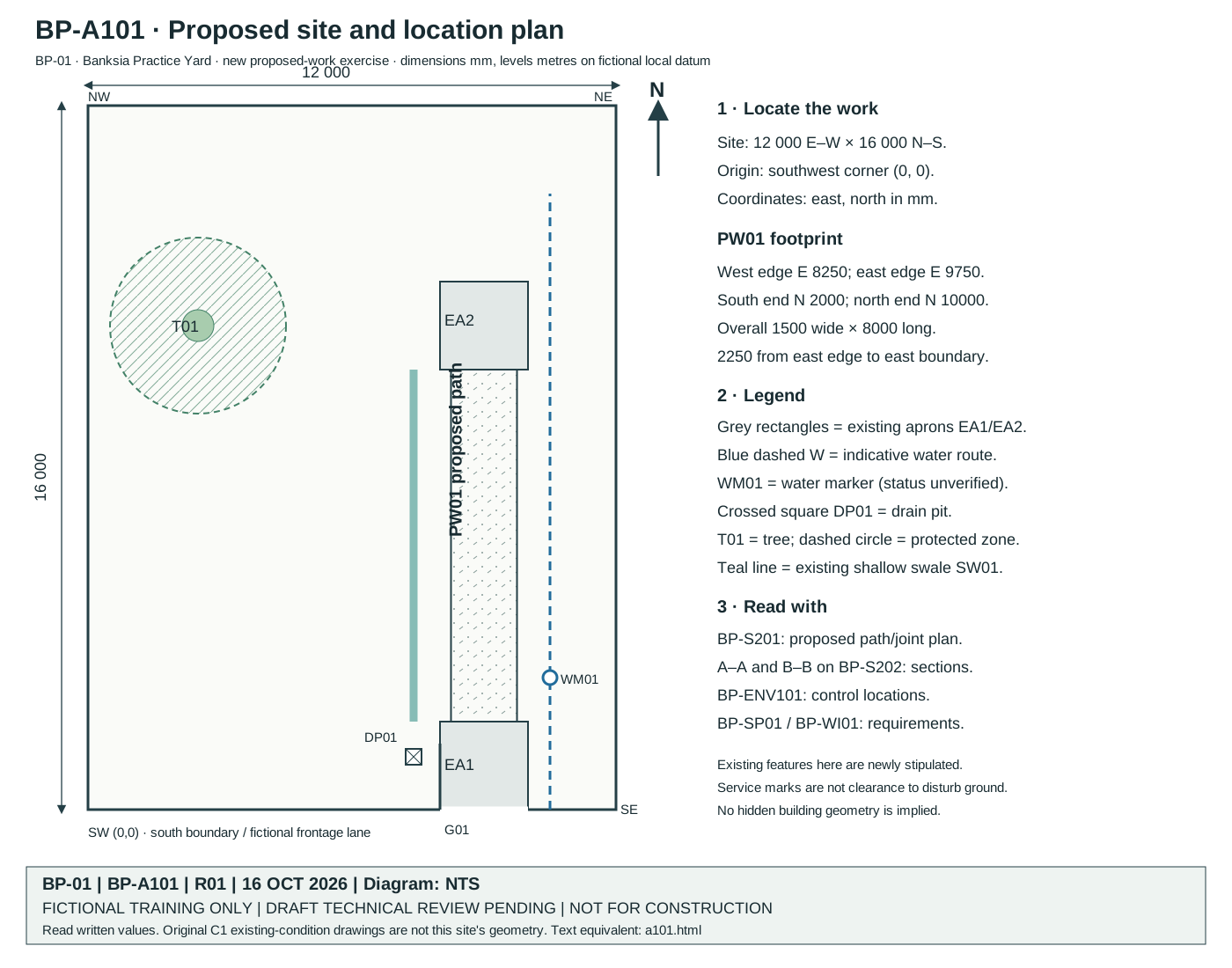
Identity, north and datum
Project BP-01, proposed path PW01, revision R01. North is at the top. The fictional site is 12 000 mm east–west and 16 000 mm north–south; its southern edge fronts the exercise access lane. Coordinate origin is the southwest corner (0,0); E increases east and N increases north. All coordinates are mm. Levels elsewhere in the set are metres on a fictional local datum, not AHD.
Site locations and boundaries
| Item | Stipulated source information |
|---|---|
| Boundary corners | SW (0,0); SE (12000,0); NE (12000,16000); NW (0,16000). |
| PW01 proposed path | West edge E8250; east edge E9750; south end N2000; north end N10000. Overall 1500 × 8000. East-edge setback to east boundary 2250. |
| G01 gate | South boundary opening from E8000 to E10000. |
| EA1 existing entry apron | E8000–10000, N0–2000. |
| EA2 existing northern apron | E8000–10000, N10000–12000. |
| WM01 water marker and W route | Marker at (10500,3000); indicative water route E10500 from N0 to N14000. Actual depth, isolation and live status are not established. |
| DP01 drain pit | Centre (7400,1200). |
| SW01 shallow swale | Centreline E7400 from N2000 to N10000; retain and protect. No new outlet design is supplied. |
| T01 tree / protected zone | Tree centre (2500,11000). Protected-zone radius 2000. |
Legend and references
| Mark | Meaning in this pack |
|---|---|
| PW01 / stippled rectangle | Proposed plain concrete pedestrian path. |
| EA1 / EA2 / grey fill | Existing exercise aprons. |
| W / blue dashed line | Indicative water-service route; status unverified. |
| WM01 / small circle | Water-service reference marker. |
| DP01 / crossed square | Drain pit. |
| T01 / tree circle | Tree; outer dashed circle is the protected zone. |
| SW01 / teal line | Existing shallow surface swale. |
| NTS | Not to scale. Read written dimensions. |
| EL | Exercise level in metres on the fictional local datum. |
Follow PW01 to BP-S201, then A–A and B–B to BP-S202. Use BP-ENV101 for environmental instructions and BP-WI01 for inspection/service limits.