
The Site Before the Visit
Read a site’s existing records, boundaries, easements, services and surrounding context before planning an informed inspection.
A place already connected to other places
A site does not begin at the front gate. Water, access, sunlight, services and neighbourhood activity connect it to land beyond its boundaries. A drawing that shows only the proposed building can conceal those relationships before the design has even begun.
Imagine a modest professional office proposed on an existing urban lot. The street provides its public approach. A neighbouring wall affects outlook and shade. A drainage easement crosses part of the land, and existing services appear in several supplied records. Each condition can influence what the site offers and what needs investigation.
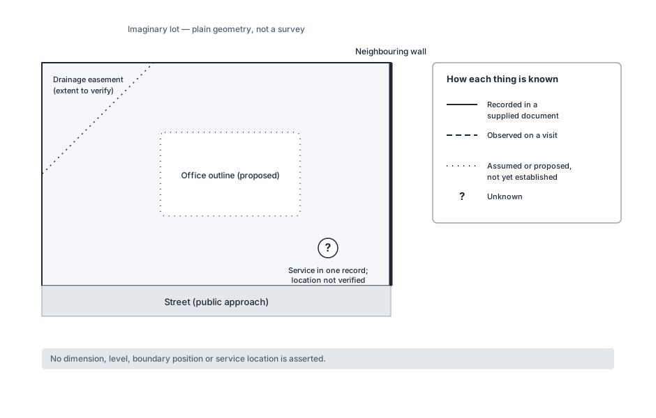
One site record, marked by how each thing is known
One imaginary urban lot with a proposed office on it, each statement marked by how it is known.
- Observe
- Compare the key with the items shown. Which categories are present, and which would need a visit or further records?
- Interpret
- Separating what is recorded from what is assumed shows where the design still depends on investigation rather than evidence.
- Do not infer
- This is not a survey, boundary determination or service location. Verify the legal easement extent against its instrument before relying on it.
- Try next
- Mark up a site plan you already have with the same four categories and see which one grows fastest.
Sources and limits for this figure
Original fictional teaching diagram created for this Fieldbook.
An imaginary urban lot has a public approach at the street and a neighbouring wall recorded in supplied information. A dotted office footprint is a proposed position, not an observed building or an authorised location. A dotted easement extent is tentative and must be checked against the actual instrument.
The key distinguishes recorded information, visit observations, assumptions or proposals, and unknowns. Dotted geometry marks the proposal and tentative extent. A question mark identifies a service recorded in one document whose location is not verified. The dashed observed-on-visit category is explained in the key, but this before-visit example supplies no observed item.
These categories describe how information is known; they do not validate it. No dimension, level, boundary position or service location is asserted, and no real land is depicted.
Original fictional teaching diagram created for this Fieldbook; not a survey, boundary determination or service location record.
Source and rights:Original fictional teaching diagram
Created for this Fieldbook from chapter 4, sections 'A place already connected to other places' and 'Several records of the same land'. It is an illustration of a record, not a record of real land.
The example is deliberately non-residential. Reading a site is useful across different building uses. The relevant scope and construction type still need to be checked. Examining context should not assume that every project is a detached house.
Before visiting, establish what the inspection is meant to inform. An early feasibility study may need broad constraints and relationships. An alteration project may require detailed information about an existing building. A visit planned without that purpose can gather many photographs while missing the measurements that matter.
The client brief helps define the questions. What activities are proposed? Which existing features are intended to remain? What information is already available? Answers guide the collection plan, while uncertainty identifies matters to resolve before relying on the site record.
Reading the qualifications on a real survey
The source companion links a Nemco detail survey for 45 Hillcrest Avenue, Greenacre, in New South Wales. Its sheet is dated 15 November 2023. Look first at the title and notes, then at the drawn site. The notes identify the Australian Height Datum, abbreviated to AHD, and a named survey mark as the origin of levels. They also distinguish approximate contours, visible services and documentary boundaries that were not field verified.
Those qualifications change how the sheet can be used. A spot level, a contour interpolated between observations and a boundary taken from records do not have identical evidential status. Their different line shapes are only part of the story; the notes explain the information behind them. A fence beside a boundary line does not remove the boundary qualification.
This is a document-reading example. Its named site and dated observations do not establish today's conditions or authorise setting out a building. The companion directs you to the full sheet so that the limitations stay beside the geometry.
Several records of the same land
A title record, a survey plan and a feature survey can refer to the same land while describing different things. Treating them as interchangeable makes it easy to carry an unsupported assumption into the design.
Land-title information concerns the registered land and interests recorded against it. The exact system and terminology depend on the jurisdiction. In Victoria's official guidance, a title search includes the land description, registered proprietors, encumbrances and a diagram reference. An instrument search retrieves the documents behind relevant references.
That distinction explains why a brief notation may not contain the whole information needed for a design decision. The title can point to another document whose terms matter. It is not a current measurement of every fence, tree, drain or building on the property.
A cadastral plan concerns the parcel framework and its boundaries within the relevant surveying system. Cadastral means relating to land parcels and their recorded boundaries. A plan's dimensions and identifiers need to be interpreted through that system, not treated as instructions for casually recreating a boundary with a tape.
Queensland's official boundary guidance makes this limit explicit. A fence, a kerb or a position from the Global Positioning System, usually called GPS, cannot substitute for the appropriate boundary determination. A digital parcel outline displayed over an aerial image is useful for orientation, but it does not establish the boundary's exact position on the ground.
A feature and level survey records defined physical information such as buildings, surface features and levels. Its value depends on its actual scope, methods and date. Read what the surveyor has identified and what the document does not claim to establish.
One local-government example shows the distinction clearly. The City of Stirling in Western Australia separately requests title, site-plan and endorsed feature-survey information for specified commercial development applications. Those documents answer complementary questions. The local requirements should not be turned into an identical national checklist.
For any supplied record, correlate the address with the parcel identifier and the project. A street address is convenient for people, while a parcel reference connects the work to the land record. An address alone can be ambiguous where lots have been subdivided, consolidated or developed in stages.
An easement has a purpose and terms
An easement concerns a defined right over land. Its purpose may relate to access, drainage or utilities, among other matters. It is different from simply owning the strip of ground that appears shaded on a plan.
Landgate's Western Australian guidance explains that the relevant documents can define conditions, including the extent and nature of rights. The visible plan notation may identify an area while a referenced instrument contains terms that affect its use. Both can matter to the designer.
Imagine our office site has a marked drainage easement near its rear. The notation raises questions about the proposed building, access and any work within that area. It does not justify a blanket assumption that all building is prohibited, or that any building is permissible if no pipe is visible.
The purpose and terms need appropriate interpretation. The responsible designer may need advice from the relevant authority, service owner or legal professional. The drafter preserves the notation and its source so that the question remains visible while the design develops.
An unused-looking track or dry channel does not prove that a recorded right has disappeared. Physical appearance and legal status are separate evidence. Equally, the visible position of a service does not necessarily describe the full extent of the right associated with it.
The useful habit is to connect the plan reference with its supporting document and identify the proposed work affected. This makes the uncertainty specific. It is more informative than colouring a strip on a drawing and assuming that everyone will understand its implications.
Services shown and services established
Water, sewerage, drainage, electricity and communications connect a building to wider networks. Some parts are visible, such as pits, meters, poles or overhead lines. Others are concealed. A site inspection and a supplied service plan contribute different information about them.
Before You Dig Australia provides a national referral service through which participating asset owners supply information. The responses come from those owners. The service's guidance treats plans as indicative and warns against assumptions about depth or a straight route between visible features.
Its membership is not complete evidence of every asset that may exist. Private services and other unrecorded or unrepresented infrastructure can remain relevant. Receiving several responses does not establish that nothing else is present.
A pit visible in a photograph supports a record of that pit's location and appearance. It does not reveal every connection beneath it. A line on an owner plan indicates supplied information, while a verified location depends on an appropriate locating process. Keep those states distinguishable.
For our office example, an indicated service corridor may affect the possible building footprint or access arrangement. The early design can identify that dependency without pretending the service has been physically located. More specific decisions require more specific information.
Overhead services also matter. They can affect access, equipment movement and future work around the building. A measure-up should not focus so closely on ground features that it ignores conditions above them.
Desktop service research does not authorise intrusive investigation. Driving a peg, opening an enclosure or disturbing ground introduces separate risks and requirements. If the inspection needs that kind of work, the collection method must be reconsidered through the appropriate controlled process.
Reading the neighbourhood
The surrounding development helps explain how the site is used and experienced. Building heights, setbacks, roof forms and the spacing between structures influence enclosure, outlook and light. Street activity affects approach and access. Vegetation can provide shade while introducing other design considerations.
Record these relationships with enough context to interpret them. A close photograph of a neighbouring window may show its form but conceal which building it belongs to. A wider view and an identified viewpoint can connect it to the site sketch.
Separate observation from assumptions about use. A building that looks residential may contain another activity. A quiet street during a mid-morning visit may behave differently at school arrival time or during deliveries. The time of an observation can explain its limits.
Our office proposal may generate visitors as well as staff movements. Its public approach therefore needs to be understood in relation to the street, pedestrian movement and existing site access. An opening in a fence does not establish that the proposed vehicle access is approved or suitable.
Access and egress describe movement into and out of a place. The design needs to consider the intended users, their mobility and the activities involved. A route suitable for one purpose may be unsuitable for another, such as deliveries, maintenance or emergency response.
Architectural context also deserves more than a list of style labels. A repeated verandah line may shape a street's character. A pattern of openings or materials may establish a relationship between buildings. Understanding that pattern is different from copying isolated decoration onto a new design.
Climate at the scale of the site
A regional climate description gives a broad starting point. The site adds local conditions: orientation, shelter, topography, vegetation and nearby structures. These influence the way sunlight, wind and weather reach the proposed building.
An aerial image can help identify orientation and surrounding development. It cannot show every current obstruction or establish shading at every time of year. Its capture date and the sun position in the image matter. A dark area may represent a shadow at that moment rather than a permanently shaded place.
On site, note the visible conditions and the time they were observed. The relationship between a building and a large tree can be important even when no shade falls on it during the visit. Seasonal foliage, growth and future management may require further investigation.
Wind conditions also need careful interpretation. A sheltered visit on a calm day does not establish a sheltered site under all conditions. Broad exposure, local obstructions and the building's form can influence wind effects. Structural wind information requires its appropriate source and design process.
Climate research therefore has several layers. Regional guidance helps explain likely design strategies. Site information helps examine local opportunities and constraints. Product and design analysis then address the particular proposal. None of those layers should be silently substituted for another.
Planning a safe inspection
An inspection plan connects the information needed with a safe way to obtain it. Confirm access arrangements, the person to contact and the nature of activity on the site. An occupied property and an operational construction site may require very different arrangements.
Safe Work Australia's induction guidance identifies the importance of information about hazards, restricted areas, emergency arrangements and supervision. Task-specific instruction should address the work actually being undertaken. The exact requirements depend on the jurisdiction, workplace and site conditions.
The collection method should change when the planned access exposes someone to an uncontrolled risk. A missing dimension does not justify entering an unstable area or climbing an unsuitable object. The record can identify the inaccessible feature and the reason further information is needed.
Consider measuring an opening above a stair. The information may be useful, but the easiest-looking route to reach it may be unsafe. The team can consider a different observation method or arrange appropriate access and expertise. A note that the dimension remains unverified is preferable to an unsafe improvisation.
Weather, uneven surfaces, traffic and interactions with other work can affect even a short visit. Appropriate clothing and protective equipment may be part of the arrangements, but they do not remove the need to plan exposure and access. Equipment should be selected for both the measurement and the conditions in which it will be used.
Choosing what to take and what to leave open
The inspection purpose guides the equipment. A tape can measure accessible distances between clear endpoints. A laser distance measurer may assist with suitable targets and sight lines. A string line can provide a physical reference in an appropriate controlled setup. Their different functions are examined in the next chapter.
Field-recording materials are equally important. A sketch needs enough space to relate dimensions to features. Photographs need identifiers that can be connected to the sketch. Batteries, storage and readable source documents affect whether the visit produces usable information.
A prepared record can distinguish supplied information from new observations. It can also reserve a place for unresolved matters. These distinctions make the later drawing more reliable because the evidence does not lose its identity during transcription.
The plan should identify where another professional's information is needed. A basic measure-up does not replace a boundary survey, a geotechnical investigation or a service-location process. Recognising those dependencies early avoids collecting a large quantity of data that cannot answer the decisive question.
The result of desktop research is therefore more than a folder of downloads. It is an understanding of the site's context, the purpose of the visit and the evidence still needed. The visit can then test and extend that understanding through observations whose meaning remains clear.